


Qijiehe River
Location:
Home
>
Geosites
> Qijiehe River
30-Dacaokou tiankeng and Xiaocaokou tiankeng
Timer:2015-03-25
They develop in pairs in the downstream of Qijiehe River. Qijiehe River runs from southwest and goes towards northeast and then flows to underground eventually. They are surrounded by precipice and steep cliff with the height of 265-330m. At the Tiankeng bottom, plants grow luxuriantly, and many animals such as birds, frogs and butterflies can be found. In tiankeng, there are many scenic spots like Tiangu natural bridge, Dacaokou precipice, triangular facet, and Dacaokou karst breccia stratum, etc.. Tiangu Natural Bridge is the boundary of two tiankengs.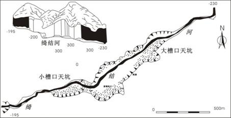
Dacaokou Tiankeng and Xiaocaokou Tiankeng (according to He Wei, Li Bo, et al., 2011)
Main development parameters of Dacaokou tiankeng and Xiaocaokou tiankeng
| Name of Tiankeng | Development stratum | Entrance form | Elevation of the bottom (m) | Entrance diameter (m) | Entrance area (m2) | Max. depth (m) | Min. depth (m) | Total capacity (M m3) | Level/Genetic type |
| Dacaokou | T1yn1 | Long strip shape | 1000.5 | 905X370 | 226800 | 330 | 265 | 55.65 | Super-large/collapse pit |
| Xiaocaokou | T1yn1 | Ellipse | 1080 | 325X180 | 45925 | 220 | 205 | 8.91 | Large/collapse pit |