


Daluoquan Tiankeng and Xiaoluoquan Tiankeng are distributed at the northwest bank of Qijiehe River in pairs, only 145m from Qijiehe Gorge in horizontal distance.
They are distributed over the northwest bank of Qijiehe River in pairs, only 100m away from each other. They are surrounded by vertical and closed precipices, and it is flat at bottom where clay with different thickness stacked.
Daluoquan Tiankeng is low in northwest and about 15-165m in height. There is a slope in the upper part, and the vertical distance from slope top to bottom is 38.5m. People can enter the bottom from the slope. While other precipices are all steep cliffs with the height of 170-220m.
Xiaoluoquan Tiankeng is located at north of Daluoquan Tiankeng with the distance of only 100m. Xiaoluoquan Tiankeng is surrounded by vertical and closed precipices, and it is low in the southwest with the height of about 70m.
Daluoquan Tiankeng is connected with Xiaoluoquan Tiankeng, which were formed by the collapse of two cave chambers which were located at the same underground river.
At present, the bottom of the two tiankengs is covered by soil, and it has been developed to cultivated land. In the season of rape flower blossom every year, the rape flowers burst into bloom, bees and butterflies fly among the flowers, which present a beautiful picture of spring dance; in summer, all kinds of crops grow luxuriantly to form a green tiankeng lake; in autumn, fruitful crops dress up the tiankengs to a golden lake; in winter, white snow covers the tiankengs, and it looks like that the tiankengs are in a white cotton-padded jacket.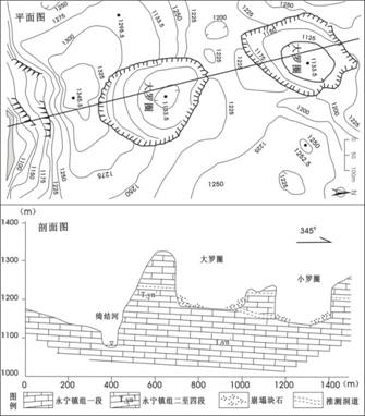
Daluoquan Tiankeng and Xiaoluoquan Tiankeng (according to He Wei, Li Bo, et al., 2011)
Main development parameters of Daluoquan Tiankeng and Xiaoluoquan Tiankeng
| Name of Tiankeng | Development position | Development stratum | Entrance form | Elevation of the bottom (m) | Entrance diameter (m) | Entrance area (m2) | Max. depth (m) | Min. depth (m) | Total capacity (M m3) | Level/ Genetic type |
| Daluoquan | Northwest bank in the downstream of Qijiehe River | T1yn2-4 | Ellipse | 1185 | 350X278 | 78380 | 220 | 155 | 8.32 | Large/collapse pit |
| Xiaoluoquan | T1yn2-4 | Ellipse | 1142 | 336X260 | 68578 | 165 | 127 | 5.75 | Medium/collapsed |