


Qijiehe River
Location:
Home
>
Geosites
> Qijiehe River
32-Jiayandong Tiankeng
Timer:2015-03-25
It is located in the slope of gorge, south to Qijiehe River, where the west cliff of tiankeng is weathered seriously, and the rest belongs to bed rock escarpment, and there is a cave at the bottom of north cliff, which is called Jiayandong Cave. The bottom is covered by collapsed rock and soil with flourishing plants growing.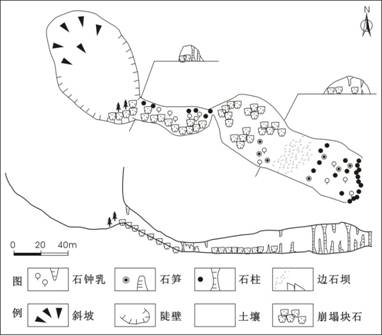
Plan and Profile Map of Jiayandong Tiankeng (according to He Wei, Li Bo, et al., 2011)
Main development parameters of Jiayandong Tiankeng
| Name of Tiankeng | Development position | Development stratum | Entrance form | Elevation of the bottom (m) | Entrance diameter (m) | Entrance area (m2) | Max. depth (m) | Min. depth (m) | Total capacity (M m3) | Level/ Genetic type |
| Jiayandong Cave | South bank at downstream of Qijiehe River | T1y2 | Ellipse | 1195 | 126X60 | 5935 | 65 | 40 | 0.23 | Small/collapsed |